
Proposed Variation 2 – Coastal Natural Hazards Mapping
Recording of Public meeting for Variation 2 on 8th August
Further Submissions on Variation 2 Coastal Natural Hazard Mapping Invited
Variation 2 to the proposed Te Tai o Poutini Plan, to update the coastal hazard mapping in the Plan, is based on newly available and more accurate LiDAR data.
Submissions for Variation 2 closed on Friday 30 August 2024 at 5.00pm.
A total of 112 Submissions were received. These are summarised by submission point here: Summary of Submissions.
The Summary of Submissions and invitation for Further Submissions were publicly notified on 11 October 2024: Public Notice.
Further submissions may only be lodged on the submissions received by the following persons or organisations:
- Any person or organisation representing a relevant aspect of the public interest;
- Any person or organisation that has an interest in the Variation that is greater than that of the general public. This includes anyone who lodged an initial submission; and
- The four local authorities affected by the Variation.
Further submissions can only be about the points raised in one or more of the submissions in the Summary of Submissions table and can only be to express your support or opposition to all or any part of the submission(s). There is no opportunity to raise new points or support/oppose points not identified in the summary of submissions. If you make a further submission, you can be heard in support of it, and you also have the opportunity to present a joint case with others who make similar submissions if you wish.
Further submissions must include information in Form 6 required by the Resource Management Act 1991 and must state whether or not you wish to be heard in support of your submission.
Further submissions close at 5.00pm on Friday 25 October 2024.
Within five days of a further submission being lodged, any further submitter must also serve a copy of it on the submitter whose points were supported or opposed. Contact details for the initial submitters are here: Contact List.
The Hearing for Variation 2 is scheduled to take place during the week 17 to 21 March 2025, and will include Hearings in Westport, at the NBS Theatre, Monday 17 to Tuesday 18 March 2025, and in Hokitika at the RSA on Thursday 20 and at the St Johns Room Friday 21 March 2025. All submitters and further submitters will be kept updated about the further submissions received and the scheduled hearing.
What is proposed?
Coastal hazards (coastal erosion and inundation) in the proposed TTPP were mapped using the most accurate data and modelling available at the time. High accuracy LiDAR data was available for the Hokitika and Westport township areas as it had already been carried out for the planning of coastal and river protection works for those towns. The rest of the coast was mapped using lower accuracy space shuttle data.
More recently, improved LIDAR data like that used in Hokitika and Westport has become available for the remainder of the coast excluding the area north of Hector and south of Jackson Bay. This has meant the modelling work has been able to be updated to be more accurate. The TTPP Committee is proposing a variation to the Plan to update the mapping accordingly.
The coast from the northern bank of the Taramakau River to Cobden (including Greymouth), from Hector north to Kahurangi Point, and south of Jackson Bay are not included in this variation to the Plan as updated data and modelling for those areas is still being developed.
How does this impact me?
The new mapping updates three of the hazard overlays which determine the rules that
would apply:
– Coastal Hazard Severe
– Coastal Hazard Alert
– Coastal Hazard Setback
These hazard overlays were included as part of the proposed TTPP, but the new mapping
Variation updates these.
The impact of the new mapping varies in different areas. It shows increased coastal hazard
risk for some properties and reduced risk for others. Some properties may have larger or
smaller areas of the hazard overlays on them, for other properties there might be a change
from one type of hazard overlay to another, or a combination of these things.
The level of coastal hazard risk on a property influences the activities that can be
undertaken there, so it is important you are aware of the proposed changes and take the
opportunity to have your say.
What rules apply?
The rules do not have legal effect until decisions on the proposed Plan are made after the
hearing of submissions. However the rules currently say:
Within the Coastal Hazard Setback Overlay
– There are no rules that apply to existing buildings
– A resource consent (restricted discretionary activity) to build a new house is required
– this will need to include a natural hazard assessment saying how the house will be
designed and built to ensure it is safe from the coastal hazards.
Within the Coastal Hazard Alert Overlay
– Existing buildings can stay in their location and if destroyed can be rebuilt
– Additions and alterations to existing buildings where there is no increase in habitable
rooms (like bedrooms or living areas) are also permitted
– New unoccupied buildings like garden sheds or garages are able to be constructed
– New houses, and addition of bedrooms or living areas require a Discretionary Activity
Resource Consent. In order to get approval to build, this would require detailed
technical evidence to show that the coastal hazard risk is mitigated.
Within the Coastal Hazard Severe Overlay
– Existing buildings can stay in their location and if destroyed can be rebuilt
– Additions and alterations to existing buildings where there is no increase in habitable
rooms (like bedrooms or living areas) are also permitted
– New unoccupied buildings like garden sheds or garages are also able to be
constructed
– New houses, and addition of bedrooms or living areas require a Non-complying
Activity Resource Consent. The proposed Plan has strong policy discouraging new
development in this overlay. Applicants would need to prove that the proposal is not
inconsistent with those policies with detailed technical evidence supporting that
position.
The Variation does not propose any changes to the Rules and submissions on
these have closed and will be heard in March 2025.
How to find out more
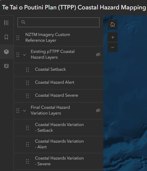
View the changes for yourself online
The map viewer at this link will allow you to view the existing coastal hazard mapping and compare it with the mapping in Variation 2. Turn layers on and off by first clicking on the symbol on the left side of the bar that looks like layers of paper, and then clicking on the small ‘eye’ symbols on the right side of the bar (as shown below). This will make interpretation easier.
Questions
All queries regarding this proposed variation or the TTPP in general can be addressed to the TTPP Team at info@ttpp.nz, 03 768 0466, or 0508 800 118.
For more information about this variation and an evaluation of the proposed changes, please read the report prepared in accordance with section 32 of the Resource Management Act 1991.